


Albuquerque’s Aquifer Must Be Protected from Water Bankruptcy That’s Headed Our Way
Other New Mexico Aquifers Are in Post-Crisis Failure
We keep reading and hearing that the Rio Grande is facing a water crisis. So are other rivers in New Mexico, across the southwest, and around the globe. But, as pointed out in a 2026 article from a United Nations water institute,[1] “Water crisis has become the default label for almost any episode of water stress, from short-lived droughts to decades-long overuse of rivers and aquifers.” The UN author contends that many times the conditions frequently described are not a “crisis” but actually represent a “post-crisis failure state”: their critical water supplies have been depleted beyond their sustainable hydrological budgets.
For such conditions, the UN author proposes that instead of saying “water crisis” a more appropriate term for such declines in an aquifer is Water Bankruptcy. He equates consuming surface water supplies with making withdrawals from checking accounts, whereas using water supplied from aquifers as making withdrawals from savings accounts. Thus, when continued groundwater pumping trends toward depleting the available aquifer supplies, that condition is equivalent to approaching bankruptcy, a post-crisis failure state.
Climate Warming and the NM Water Supply
First, why should we be concerned about the future of the water supplies along the Rio Grande and elsewhere across NM and the SW? Clearly, as we read, the climate around the globe is warming at an increasing rate. As described elsewhere,[2] this is producing changes in our atmosphere’s global circulation patterns that are projected to make NM air temperatures much warmer, as we are now experiencing in 2026, with later winter and early spring feeling much like summer.
In 2022, a New Mexico Bureau of Geology and Mineral Resources (NMBGMR) report projected that[3], “Over the next half century, profound changes in New Mexico’s climate will affect water resources all across the state. All evidence suggests that surface temperature will continue to rise throughout New Mexico over the next 50 years. Most projections of statewide annual mean temperature are from 3°F to 7°F warmer than the late 20th century, and some high-end models predict even more warming.” That is bad news.
But even worse, a recent analysis[4] of “really good” weather data for seven-day periods in Albuquerque going back to the 1930s, found that “no seven-day period” in any year has come anywhere close to the National Weather Service’s determination that March 19 to 25, 2026 is about 28oF above any seven-day average. That is more than four times outside the normal range of variation in Albuquerque’s air temperature for any seven-day period. This points to the likelihood of even greater and earlier effects to NM water resources due to climate warming than anticipated in the NMBGMR assessment. Thus, we should be very, very concerned about the future water supplies along the Rio Grande, as well as across NM and the SW!
Groundwater Mapping and Monitoring in NM
Applying the concept introduced by that UN proposed terminology to NM we might ask, is the Rio Grande or other groundwater basins in New Mexico heading toward bankruptcy? To approach this question, information available online from the New Mexico Groundwater Dashboard (NMGD) can be helpful.
NMBGMR is New Mexico’s non-regulatory water science agency. It produced the NMGD to provide public access to a relatively comprehensive long-term set of groundwater mapping and monitoring data. As the site’s welcome message emphasizes, “Wells are our window into the otherwise unseen realm of groundwater. In addition to producing water, groundwater-level data can also be obtained from water wells that can help us manage New Mexico’s groundwater resources.”
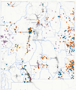
That site’s interactive map shows the locations of all of NM’s known groundwater wells and indicates for the wells that are monitored, which wells have trends of water level increases (green), decreases (red), or unchanged (yellow, Figure 1). Of the 268,405 wells located on that map, 2,323 have monitoring data. The site also reports that many of these wells are not specifically designed for monitoring; instead they are active production wells that also provide less accurate information on water level trends. The information on this site’s map comes from multiple sources, including monitoring data from the NM Bureau of Geology and Mineral Resources and the United States Geological Survey as well as the well locations from the NM State Engineer permit files.
Figure 1 shows that the greatest density of monitored wells along the Rio Grande is around the Albuquerque-Santa Fe reach and along the southern Rio Grande. Also, a considerable density of monitored wells (and particularly red icon wells representing declining water levels) occur in the eastern part of the state. Proportionally fewer wells and monitoring information comes from the area west of the Rio Grande drainage, with relatively fewer monitoring wells with red icons.
Clicking a colored icon on the dashboard brings up specific information for that well with additional options to display a graphic for the well’s aquifer water level over time and another graphic displaying the deviation (gain or loss) of these levels from the average for the well’s available data. An additional option is available to display the water level data measured for the well that were used to make the two graphics. Of note, groundwater depth information is not necessarily collected every year and some years have more than one measurement recorded. A few wells have continuous monitoring, including the intentionally installed three-dimensional network in metropolitan Albuquerque.
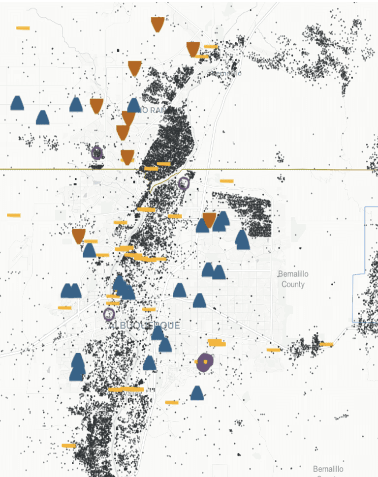
Zooming in on the NMGD map (Figure 2) shows the actual density and locations of both monitored wells with colored icons and the density of black permitted well surrounding the Rio Grande and Albuquerque areas. Most of the icons in this area are blue or yellow indicating that the aquifer accessed by these wells is gaining or remaining largely unchanged based on the well’s monitoring data. There are relatively fewer monitoring wells with red icons.
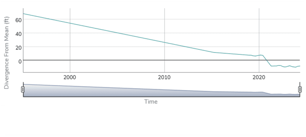
Clicking on the red icon on the NMGD site for the well at the top of Figure 2, we learn it is a USGS monitoring well located in a remote area (GPS: 13N03E.21.3124). From 1978 to 2025, its aquifer has decreased to a current depth to water of 446.8 feet. That water level is 7.8 feet below the average water depth for the site (Figure 3). That suggests that the aquifer in this area is perhaps heading toward or is in bankruptcy under the UN defined term.
The Albuquerque Area Aquifer
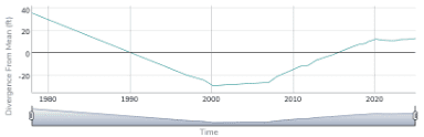
Clicking on the blue icon on the NMGD site for the eastmost well in Figure 2 we learn that it is located 11N.04E.28.131 WKR 4, which is near the intersection of Academy and Eubank. This USGS monitoring well currently has a groundwater increasing trend, with a current depth to water of 714.83 feet that is 13.17 feet above average (Figure 4). Of note, however, the data for this well shows that from the 1970s to 2000 this aquifer had a continual trend of declining aquifer depth. In 2000 it started having a slow increase in water depth that started a more rapid rise in aquifer depth starting about 2017-2018 then leveled in 2020 through the following monitoring years in this data set.
From this brief review of the NMGD site data for these two sites and information from other monitoring well sites included in Figure 2 reviewed but not characterized here, it is reasonable to conclude that, at the present time, the Middle Rio Grande aquifer overall would not be appropriately characterized as in bankruptcy.
For some areas in the north and to the west (along the edges of the Middle Rio Grande aquifer), however, such a characterization would appear to be at or approaching appropriate. Plus, the fact that other parts of this aquifer displayed earlier periods of decline followed by periods of increase. That indicates the overall middle Rio Grande aquifer is of considerable risk of moving to bankruptcy should the current trends for climate warming and winter snowpack reductions, with early runoff, continue to decrease surface water supplies to the Rio Grande.
In fact, with the ongoing federal approach of viewing climate warming to be a hoax, not worth addressing, even greater threats of declining water supplies across the Southwest are increasingly likely. This argues that the regions along the Rio Grande require State water resource agencies to actively manage uses. Local governments must cooperate and take ownership of leading their constituents as soon as possible to conserve necessary long-term water availability for existing uses, including low water use economic development.
The High Plains Aquifer
In contrast, the preponderance of monitoring wells in eastern NM with red icons, indicating this region’s declining aquifer water levels, strongly suggests that these are aquifers in bankruptcy. The New Mexico State Engineer decided about a century ago that the State would allocate the water to use it for a reasonable time, which is essentially over. Groundwater expert Maurice Hall argues that the least we should do is plan for “graceful failure.” More than that is needed.
Without implementing active water management for regional water supplies, NM is likely to become characterized as having declining economic promise, perhaps with consequential depopulation trends. Alternatively, The State could wait for NM to somehow deliver one of its enchanted solutions for climate warming and our declining aquifers.
Needing more information?
Additional information on NM’s ground water resources is available from the NM Aquifer Mapping and Monitoring Program (AMMP) of the NMBGMR.[5] The information provided through this site establishes that, “By mapping aquifers and establishing a long-term monitoring network, the program generates essential insights into how groundwater moves, where it’s stored, and how it changes over time. Through the ongoing philanthropic support of the Healy Foundation, AMMP created the Collaborative Groundwater Monitoring Network. This network provides critical, baseline information on groundwater trends through collaborative data collection and regular measurements of depth to water across the state. State funding will enable this program to drill new monitoring wells in strategic locations, addressing questions about water quality, water depth, and filling critical gaps in subsurface knowledge.” The dashboard also presents additional information about this network including showing location of its sites across NM.
Unfortunately, software and security problems have caused the NMBGMR to post that its network of monitoring data for specific well locations currently are not generally available. That signals more need for state investments to improve, modernize, and secure water agencies’ data systems.
[1] Madani, K. 2026. Water Bankruptcy: The Formal Definition. Water Resources Management https://doi.org/10.1007/s11269-025-04484-0
[2] Marcus, M. 2025. New Mexico Drought, Aridification & Desertification. https://nmwateradvocates.org/new-mexicos-water-crisis-drought-aridification-desertification/
[3] New Mexico Bureau of Geology and Mineral Resources. 2022. Climate Change and New Mexico’s Water Resources: A 50-Year Outlook. https://geoinfo.nmt.edu/publications/periodicals/earthmatters/20/n2/em_v20_n2.pdf
[4] Fleck, J. 2026. A Freakish Heat Wave – A Statistical Wonder. https://www.inkstain.net/2026/03/a-frightening-heat-wave-a-statistical-wonder/
[5] New Mexico Aquifer Mapping and Monitoring Program. https://geoinfo.nmt.edu/resources/water/amp/home.html


 The
The 


 The study authors’ basin-wide accounting of water use in the Rio Grande–Bravo Basin concludes that more than half (about 52 %) of all water consumed in the basin is unsustainable, meaning it is withdrawn faster than it can be replenished. The study finds that irrigated agriculture accounts for roughly 87 % of all direct consumptive water use, making it by far the dominant driver of depletion. Within that agricultural use, forage crops grown primarily for livestock feed—especially alfalfa and other hays—account for approximately half of total agricultural consumption, far exceeding the water use of food crops for direct human consumption. This pattern of
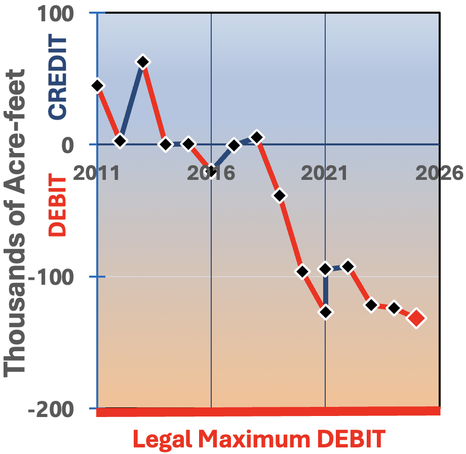 Water uses in the Middle Rio Grande have consistently over-depleted the Middle Rio Grande’s share, shorting the Lower Rio Grande. Similarly, excessive water uses in New Mexico downstream of Elephant Butte Dam are shorting Texas. Both situations have persisted for many years and are now entangled but distinct emergencies.


