The 2024 New Mexico Climate Adaptation and Resilience Plan (CARP) is under revision for publication in February 2027. The 2024 version and an early draft of the revised version treat New Mexico’s permanent drying out as a footnote. A state climate adaptation plan in the desert southwest that does not address water supply has a fundamental failure to live up to its name. The CARP’s “Water Systems” theme addresses only built infrastructure — pipes, treatment facilities, delivery systems. It does not address the present and future condition of the water supplies those systems depend on.
New Mexico Water Advocates was invited in 2025 to join the New Mexico Community Resilience Group (CRG), an advisory forum convened by the state Energy, Minerals and Natural Resources Department (EMNRD) to strengthen coordination between state and local climate resilience efforts and to help ensure that community priorities are reflected in the revised CARP. New Mexico Water Advocates participates in that group. From that vantage the plan’s treatment of water supply is woefully inadequate.
Many New Mexico communities are in or approaching water bankruptcy — a condition in which their water demands structurally and chronically exceed available renewable or long-term supply and a return to the previously normal water supply is impossible. Water bankruptcy in New Mexico is driven by decades of groundwater mining. It is created by routine upstream depletion of river water owned by downstream users. Water bankruptcy is not a future risk to be managed; for many regions and communities it is the present reality requiring adaptation now to prevent very bad outcomes including collapse. A New Mexico climate adaptation plan that does not name increasing water scarcity or prescribe a response to it is fundamentally incomplete.
The Lower Rio Grande is in water bankruptcy, and is now subject to the “Settlement,” which is really a negotiated bankruptcy recovery plan that the U.S. Supreme Court accepted, issued as a decree, and will enforce. The Governor has lauded the end of litigation, saying that it brings certainty to Lower Rio Grande communities and farmers. In reality, the water supply future for Las Cruces, NMSU, and all other municipal and self-supplied industrial and commercial water users is now extremely uncertain. Certainties include great constraints on total water use and substantial cutbacks in groundwater pumping. Compliance will cause major disruptions.
Communities across New Mexico who rely on mined groundwater as their sole source of water supply also are in water bankruptcy, including Clovis, Portales, and Cannon Air Force Base. Other communities are not yet at the end of their water supplies but are well on the way, and the community and economic consequences are being disregarded.
The Albuquerque Metro area and entire Middle Rio Grande are approaching water bankruptcy in the form of an explicit violation of the Rio Grande Compact due to unsustainable uses of the river and the aquifers beneath and beside it. If the State doesn’t act quickly and decisively to prevent that violation, the U.S. Supreme Court will eventually issue the Middle Rio Grande’s tough water bankruptcy recovery plan and enforce it.
The 2024 CARP’s failure to address water supply originates from Governor Lujan Grisham’s focus on developing “new” water and not working toward solutions to living within our means. The CARP is silent on the 2022 State Engineer’s Water Policy and Infrastructure Task Force’s unanimous water management and planning recommendations — while quoting Task Force water infrastructure recommendations.
New Mexico Water Advocates asks the EMNRD staff responsible for the CARP revision to address the following, working closely with the Office of the State Engineer and the Interstate Stream Commission:
Recognition that present and projected water supply deficits in the Middle and Lower Rio Grande basins and in regions depending exclusively on mined groundwater require adaptation now.
Integration of the Water Task Force’s eight water management and planning recommendations, unanimously adopted by the 2022 Task Force and subsequently neglected by the State, as the CARP’s omissions demonstrate.
Without changes to recognize the realities of New Mexico’s historical unsustainable water withdrawals, increasing aridification, and our existential requirement to adapt to water supply scarcity, New Mexico’s economy and quality of life will not survive.
New Mexico is progressing steadily toward water bankruptcy, a condition scientists define as a persistent post-crisis state in which water withdrawals have exceeded renewable supplies for so long that critical water resources are depleted and a return to former conditions is irreversible, even at prohibitive cost.[1] New Mexico is experiencing major decreases in surface water supplies needed to meet present and future requirements of our people and economy. New Mexicans have reacted by increasingly pumping groundwater, accelerating depletion of this dwindling resource. Along the Rio Grande and other rivers, unsustainable groundwater pumping induces recharge from the river that diverts streamflow underground, depriving downstream water rights holders of their water.
Diminishing flows in the Rio Grande Isleta reach April 9, 2026. Photo by GeoSystems Analysis published by the Bureau of Reclamation.
New Mexico Is Spending Its Water Into Bankruptcy
Unfortunately, our population appears to be generally unaware this is occurring. Regrettably, our governor, the majority of our legislators, and almost all candidates for these offices in the upcoming elections doing little to help our population learn about the true water supply emergencies we face. State water agencies are understaffed and slow. They lack the executive direction and tools, such as water metering and modern data systems, that are required for workable water governance. Their leaders take direction from a Governor who prioritizes speculative new water schemes while neglecting the stewardship and managed conservation necessary for lawful distribution of shrinking water supplies.
After all, telling the plain truth New Mexico is in a water overuse and scarcity emergency would clash with the Governor’s and the economic development community’s priority of recruiting data centers and other high water use industry.
This clash resembles that found in other southwestern states, except for Texas. Last November, 70 percent of Texas voters said yes to commit $20 billion, a first and major step to help ensure their state’s population and industries have a reliable water supply.[2]
The Texas Legislature and Voters Choose a Better Path
As reported in the Environmental Defense Fund’s (EDF) Winter 2026 quarterly magazine, Solutions, the Texas voters passed Proposition 4, creating the largest water supply investment in Texas’ history, all funded by its existing sales tax.[3] This is a significant first step to fund the $150 billion estimate budget needed for Texas to address its coming and ongoing water supply requirements.
Our claim that “New Mexico is a better place to live than Texas” needs to be backed up with actions, because water makes our lives here possible. Without water, there is nothing.
Proposition 4 initially targets building new water supply systems and helping it patch aging water supply pipes that are now estimated to leak out 30 percent of Texas’ treated drinking water supply. It also targets developing and advancing innovative and cost-effective projects for wastewater reuse, agricultural water conservation, groundwater protection, wetlands restoration, and land conservation. Like New Mexico, the Texas projects also face challenges that include the lack of legal constraints on groundwater pumping and historical water right allocations.
Seeing what the citizens of Texas have accomplished — voting 70 percent in favor of a $20 billion first step toward water security — it is well past time to do something similar in New Mexico. Our claim that “New Mexico is a better place to live than Texas” needs to be backed up with actions, because water makes our lives here possible. Without water, there is nothing. Our overuse is badly damaging New Mexico children’s future.
New Mexicans do not have the option Texas voters exercised. In Texas, a two-thirds vote of their legislature placed Proposition 4 on the ballot — and 70% of Texas voters delivered. New Mexico’s legislature has not. Our governor, our legislature, and our water agencies hold powers that citizens cannot exercise for themselves, powers that are being sorely neglected. New Mexico Water Advocates urges our state’s leaders to act with the resolve Texas demonstrated. We urge every reader to demand it. As EDF says, “It’s not just about money…. It’s about finally recognizing that water is our most precious resource, and it is time to start acting like it.”
We Must Adapt to Stop Overdrawing New Mexico’s Water Future
Two Forces Behind New Mexico’s Driest Winter on Record
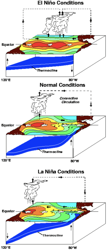
Our past winter had 70 and 80 degree temperatures in February and March. The southern Rocky Mountains had little snow that melted quite early. This has been the warmest winter in the state’s 130-plus years of record. These conditions have diminished and dried New Mexico’s rivers. Two simultaneous conditions have produced this. First, we have learned from scientific monitoring and modeling that the Earth’s atmosphere is warming at an apparently accelerating rate. Second, a La Niña pattern developed in the Pacific Ocean that pushed the prevailing east flow of the jet stream, with its carried storms, northward to the Pacific Northwest and east from there. That produced historically record-dry conditions to persist across New Mexico and the Southwest.
La Niña is the term for that part of a repeating cycle of cooling and warming of ocean waters in the east-central tropical Pacific that repeats every few years. La Niña patterns occur when the water is coolest, alternating with El Niño patterns that develop in the warmest years of this cycle. Historically, the global climate changes caused by La Niña conditions typically include reductions in rainfall across the Southwest during its traditional summer monsoon season. An El Niño can increase later summer and fall monsoons for the Southwest. Of major significance, an El Niño generally leads to significantly greater snow packs in the southern Rockies. Such changes also accompany increasing drought conditions for the northern Rockies and much of the Northwest, Midwest, and East.
Currently, climate monitoring and major climate models both indicate that a rare, record-breaking “super” El Niño is spreading eastward across the tropical Pacific Ocean toward South America. The Increasing ocean temperatures could push ocean temperatures three degrees Celsius (5.4 degrees Fahrenheit) above average. This ocean heating is projected to be larger than the previous record occurring during the super El Niño of 1886-88. That El Niño resulted in global crop failures and deaths of an estimated 50 million people due to drought and starvation. Such massive impacts are not expected to happen with this new super El Niño because our understanding of such effect has expanded, allowing for any such impacts to be better mitigated. That is not to say that regional droughts will not develop and related lesser magnitude human impacts will not result.
El Niño May Bring Temporary Relief, But Not a Solution
Seldom does a single wet season or two fully erase accumulated long-term water supply deficits.
Assuming El Niño persists for the next year or two and is not significantly disrupted by accelerating climate warming, and assuming the historical pattern of increased precipitation in the Southwest and snow packs in the southern Rocky Mountains holds, then the ongoing pattern of increased aridity across New Mexico and the Southwest could get a temporary reprieve. Forecasters warn, however, that seldom does a single wet season or two fully erase accumulated long-term water supply deficits.
Here, it is also important to remember that the Earth’s climate is also projected to continually warm. As such, we must continue to recognize that we in the Southwest are not ending a temporary drought. Nevertheless, we should expect that some folks will falsely claim “our water supply crisis is over.” Rains must not be allowed to dampen the growing political urgency around the fact that water uses across New Mexico substantially exceed the sustainable water supply.
New Mexico and the Southwest, as is also true for the global climate, are projected to be in an ongoing and perhaps never ending period of climate warming, with an increasing long-term, gradual shift of our region to a drier climate (i.e., increased aridification or even desertification, as we have discussed previously). In fact, this 2026 El Nino is projected to bump global temperatures up by three degrees Fahrenheit. Also remember, as this El Niño warming part of the southern Pacific cycle ends the next cooling part of the La Niña cycle will return drying conditions to our region.
We Must Act Before the Window Closes
We must use this time wisely to better focus and activate urgently needed water supply management for New Mexico and the Middle Rio Grande region — before our longer-term water crisis becomes water bankruptcy.
Assuming that the Southwest gets a temporary reprieve from increasing drying, we must use this time wisely to better focus and activate urgently needed water supply management for New Mexico and the Middle Rio Grande region before our longer term water crisis becomes water bankruptcy.
The New Mexico Water Advocates will continue to advocate for a balanced, equitable, and resilient water future for New Mexico through public education and civic engagement. Thank you for engaging with the Water Advocates and joining your voice to urge our state and local governments to act with the urgency the moment calls for.
Everyone must do their part. We must insist the State must do more of its part, better and faster.
The Rio Grande’s water supply in New Mexico is arguably in an even more dangerous condition than the Colorado River
by Brian Richter, Sustainable Waters
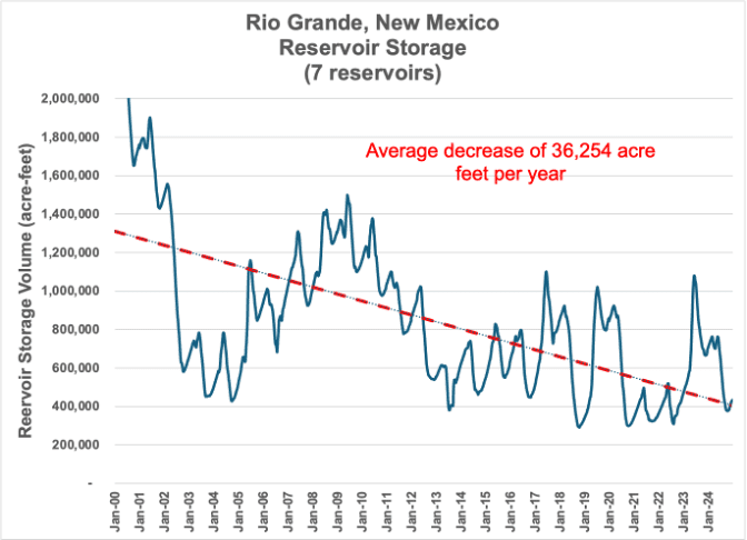
The Colorado River has been in the news headlines a lot lately because the water stored in Lake Powell and Lake Mead has been heavily depleted in recent decades, putting the water supply for 40 million people in extreme jeopardy. The Rio Grande doesn’t receive nearly as much attention as the Colorado, but the Rio’s water supply in New Mexico is arguably in an even more dangerous condition because our reservoirs are tiny compared to those on the Colorado River, and we’ve used up more than 70% of the water that was stored in our reservoirs back in 2000. This year is extremely dry, and what little is left in our reservoirs could easily be wiped out by year’s end.
Richter: “We have lost more than 70% of all water that was stored in New Mexico reservoirs since 2000.”
I’ve spent the past four decades working on water challenges in more than 40 countries. The water crisis facing New Mexico is among the worst I’ve seen.
I knew things were getting bad in the Rio Grande basin because of the increased drying of the river, but it wasn’t until we completed our recent research that I realized how fast we’re using up our available water storage. We documented that only one-third of the water New Mexicans are consuming is being replenished with snowmelt runoff, rainfall, and aquifer recharge. When we consume more water than is being replenished, we dry up our reservoirs and rivers and deplete our groundwater aquifers.
Along the Rio Grande in New Mexico, we have been depleting our groundwater reserves at the rate of more than a half million acre-feet per year. That means that every year, we’re losing a volume of water supply sufficient to provide household water for everyone in New Mexico!
I’ve spent the past four decades working on water challenges in more than 40 countries. The water crisis facing New Mexico is among the worst I’ve seen.
When reservoirs run low, cities and farmers tend to pump much more groundwater to meet their needs. Along the Rio Grande in New Mexico, we have been depleting our groundwater reserves at the rate of more than a half million acre-feet per year! If that overdraft continues, the pumping will begin to suck more and more water out of the river (known as ‘river capture’), the ground surface could begin to drop and fracture roads as well as underground pipes and utility lines, and it will become increasingly expensive to pump groundwater because electricity costs will rise as the groundwater level falls.
Our over-consumption of renewable water supplies in New Mexico is also impacting farmers and cities downstream in Texas. A recent Supreme Court case found that New Mexico’s groundwater pumping downstream of Elephant Butte Reservoir was capturing river water owed to Texas under the terms of the interstate Rio Grande Compact. As a result, more than 9,000 acres (14 square miles) of farmland irrigated with groundwater within the Elephant Butte Irrigation District will need to be retired permanently. More frightening is the fact that New Mexico’s multi-year water debt to Texas has grown to a level that could trigger another Supreme Court lawsuit from Texas that could legally curtail water uses further upstream in the Middle Rio Grande.
Restrictions on groundwater use are urgently needed to prevent this underground crisis from wreaking havoc on our rivers, infrastructure, and economy.
There are two basic strategies for resolving a water overconsumption problem: reduce consumption or increase supply.
Increasing water supplies — such as by reclaiming polluted water from oil and gas fracking — is very expensive because it takes a tremendous amount of energy to clean the water adequately and to pipe it to where it is needed. These high costs generally make any increases in water supplies too expensive for use in irrigated agriculture, which consumes 90% of the Rio Grande water used for human purposes in New Mexico. There are also legitimate concerns about the inability of water treatment processes to remove hundreds of toxic chemicals and radioactivity.
Our research suggests that our reservoirs could be stabilized by reducing our use of river water by about 5%, but greater reduction will be needed to refill reservoirs. This certainly seems attainable at present, but this target will grow as our climate continues to warm in coming decades. Much more challenging is the need to reduce groundwater pumping by more than 60% to stabilize groundwater levels. Clearly, restrictions on groundwater use are urgently needed to prevent this underground crisis from wreaking havoc on our rivers, infrastructure, and economy.
Corrections: At Brian Richtor’s May 21 request, three corrections to the April 30 version are identified in blue italics type to correct errors discovered in the published paper.
Brian Richter and colleague Enrique Prunes will present their research on water supplies across the Rio Grande-Bravo Basin. Brian’s four-decade career has helped resolve water crises in more than 40 countries. Enrique, originally from Chihuahua and now based in Albuquerque, leads Rio Grande work for the World Wildlife Fund. Together, they’ll share what the science says about the basin’s condition — and what New Mexico must do about it. Join us for this virtual workshop on May 21 at 6:30 pm — the next in Water Advocates’ monthly workshop series. Preregister now.
The State Climate Adaptation and Resilience Plan Omits Water Supply! That’s Unacceptable, It Must Be Fixed, and Here’s Why.
New Mexico is spending federal and state dollars to finish a Climate Adaptation and Resilience Plan — due for publication in February 2027 — that manages to largely miss the point. The state is drying up. Not temporarily. Not cyclically. Permanently. And the plan that is supposed to prepare New Mexico for its climate future, to guide New Mexico’s adaptation, treats that fact as a footnote.
A Plan in Name Only
The June 2024 draft plan is being finished by the Energy, Minerals and Natural Resources Department this year. The draft is not without merit. It acknowledges extreme heat, wildfire risk, and flooding. It uses acceptable language about equity and vulnerable communities. What it conspicuously, inexcusably fails to do is face the central reality of climate change in New Mexico. We are consuming far more water than our rivers and aquifers can sustain, and that gap is growing wider every year. The word “adaptation” appears in the plan’s title. The concept is almost entirely absent from its water chapter, which focuses community water infrastructure needs and ignores our shrinking water supplies.
Important Numbers and Facts Ignored
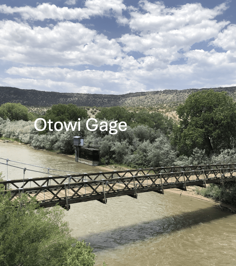
View downstream from the Otowi Bridge on the highway to Los Alamos
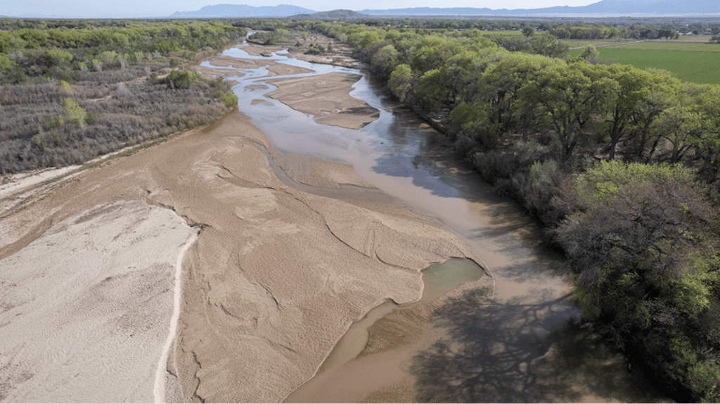
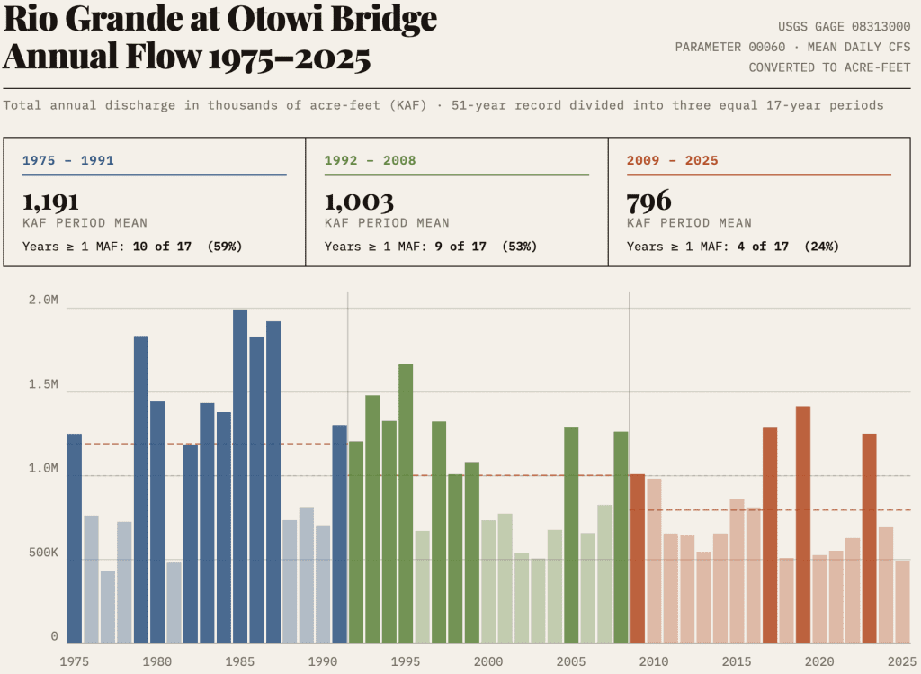
The Rio Grande at Otowi Bridge averaged slightly more than a million acre-feet per year from 1992 to 2008. From 2009 to 2025, the average annual volume was 796,000, a 20% loss. The river provided less than 500,000 acre-feet in 2025. Four of the last seventeen years produced more than one million acre-feet, compared to nine of the seventeen years before that. Everybody downstream depends on this water.
Clovis and Portales are out of water. Irrigators across the state who pump huge amounts of non-renewable groundwater to grow forage don’t know how much is left. The Lower Rio Grande Settlement will severely curtail groundwater pumping so the Texas share of Rio Grande flows will reach the state line. The river flow downstream from Caballo Dam this year and last isn’t enough to irrigate the 40,000 acres of pecans New Mexico farmers grow there. Because the Settlement is not in effect yet, the pecan farmers will continue to pump in 2026, adding to the big hole in the groundwater that the Settlement requires the State partially refill by cutting pumping.
This is not drought. Droughts end. New Mexico is undergoing aridification — a permanent, worsening shift in the hydrologic baseline driven by climate heating. The CARP uses the word “drought” throughout, as though winter snowpack will dependably return and rivers will gush again. A problem misnamed is a problem misframed.
The plan acknowledges research by New Mexico’s experts brought together by NM Tech. The experts volunteered their time because the State couldn’t pay them to write their excellent, prize-winning report! Those experts’ scientific evidence supports their conclusion that the state will lose 25% of its groundwater recharge and streamflow by 2070. But the plain truth is that we have lost half the historical amounts that flowed into Cochiti Reservoir as renewable water supply for all New Mexicans living along the Rio Grande plus the Texas share.
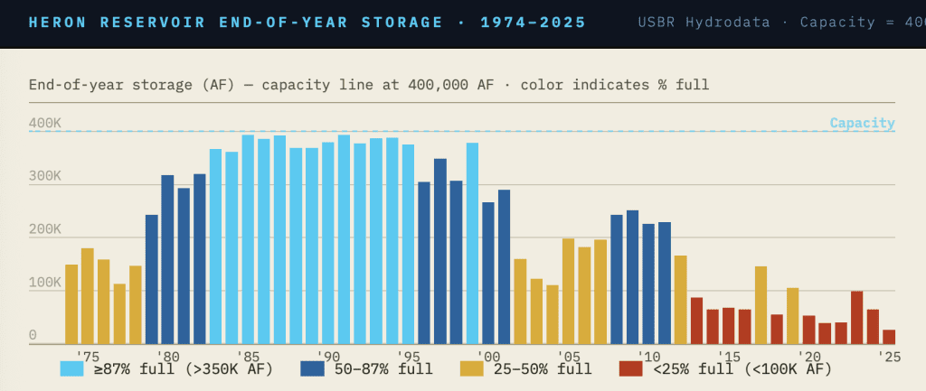
The San Juan-Chama Project is failing, producing only 39% of its “firm yield” in 2025. This year will be worse. The column chart below tracks San Juan-Chama water stored in Heron Reservoir at the end of every year since it began filling in 1978. The direction is unmistakable. Rio Grande headwaters snowpack for the 2025-2026 winter was the lowest since measurements began. It melted out before May. Historically, Rio Chama and Rio Grande peak spring flows were around Memorial Day.
The Middle Rio Grande is approaching a compact violation with severe legal and economic consequences. The Lower Rio Grande is in water bankruptcy, as are many regions of the state that depend on groundwater but have already exhausted most of it. That crisis does not appear in the CARP with anything approaching appropriate urgency.
Active Water Resource Management authority has not been applied to the Rio Grande — the river that motivated it — even though the New Mexico Supreme Court upheld the State Engineer’s rules in 2012. The 2019 Water Data Act directing agencies are not getting their data online and available to all as that law requires. The 2023 Water Security Planning Act is in its fourth year of agency preparations to start the regional water planning program, with no funds for the regional councils that are yet to be formed to do the work. Water planning requires compiled data and computer simulation models. The data are not compiled; the models are not updated and ready.
Water agencies have many competent, hard working staff but don’t have the capacity or the modern information tools they need. The failure is not the staff’s. The Governor ignores the gap between supply and demand and touts “new water” as the answer. Legislative appropriators deny funding to implement the very laws they and their colleagues passed unanimously. Is the Climate Adaptation and Resilience Plan allowed to honestly address water scarcity when the Governor and her Economic Development Department are actively recruiting new high water use industries to locate here?
The State Engineer is appointed by the Governor. She is New Mexico’s top water official with broad powers to govern New Mexico’s water. Hers is the authoritative public voice on New Mexico water, but she has not found the courage or demonstrated the leadership and public clarity the moment demands. The Interstate Stream Commission, a policy making body appointed by the Governor, has never once taken up the Middle Rio Grande compact compliance emergency in a public meeting.
This is malign neglect.
The Governor’s False Solutions
When New Mexico Water Advocates raised these failures directly with EMNRD staff, we were told the department relies on the Office of the State Engineer and Interstate Stream Commission for water policy. The staff response was sympathetic but constrained — these problems, they acknowledged, are beyond their control. True, but woefully insufficient.
Governor Michelle Lujan Grisham leaves office in January 2027. The CARP is scheduled to be published the following month. The CARP reflects her administration’s bias against tackling the combination of shrinking water supplies and our ruinous overuse of them. The Governor’s sole priority for water supply has been “new water” — reclaimed brackish groundwater and oilfield wastewater — sources that cannot close the gap we face even if the oil and gas companies’ rhetoric were true.
The Plain Truth
Meanwhile, the truth about unsustainable water use and increasing water scarcity goes unanswered by this administration. An adaptation plan that ignores our water supplies will not make New Mexico resilient.
Without water there is nothing. Adaptation to water scarcity is not optional. It is the precondition for everything else.
New Mexico deserves better — and barely enough time remains to demand it.
Articles authored by the New Mexico Water Advocates Operating Committee state the organization’s position.
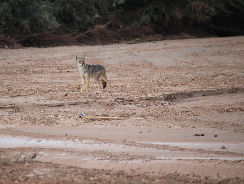
Along the stretch of the Middle Rio Grande where I frequently walk, birdsong is scarce this spring, even in the early mornings. Already, more than 40 miles of the Middle Rio Grande are dry. Reservoirs are low, irrigation season will end early, and a handful of small fires have already burned in the bosque.
Soon, when river drying moves upstream into Albuquerque, I’ll witness how the fish, turtles, beavers, coyotes, porcupines, javelina, and other wildlife suffer. Insects, bats, and other pollinators will be affected. The cottonwoods that dropped leaves when their roots couldn’t reach water last summer — yet still tried leafing out this spring — won’t survive another hot, dry year. And I have a hard time thinking about what will happen in September and October when the sandhill cranes start arriving.
Coyote walking the Rio Grande, Laura Paskus 2025 photo
Of course, it’s comforting to tell ourselves that there will be good years and bad years. Or to hope for a decent monsoon or more snow next winter.
Along the stretch of the Middle Rio Grande where I frequently walk, birdsong is scarce this spring, even in the early mornings. Already, more than 40 miles of the Middle Rio Grande are dry.
But as the Earth keeps warming and the Southwest becomes increasingly arid, the bad years hit more frequently — and much, much harder. Especially when forests and rangelands and orchards are dusty and dry all four seasons and into the next water year.
And every year the Middle Rio Grande (or any once-perennial river) dries, we lose our resilience and our ability to listen — to the river and to one another.
I first started reporting on drying in the Middle Rio Grande 24 years ago this spring. At that time, officials tried to hide the fact. Other people blamed it on “drought.” Today, we all know why the Rio Grande dries: There’s less water in the system. There are too many demands. And in states like New Mexico, rivers lack rights to their own waters.
For more than 100 years, too many of us have treated New Mexico’s rivers like ditches, pipelines, and perpetual machines engineered to serve our wants and needs. Too few of us remember that rivers have power, desire, and needs of their own. And our rivers have a lot to say — including this spring when almost all of them are extremely low.
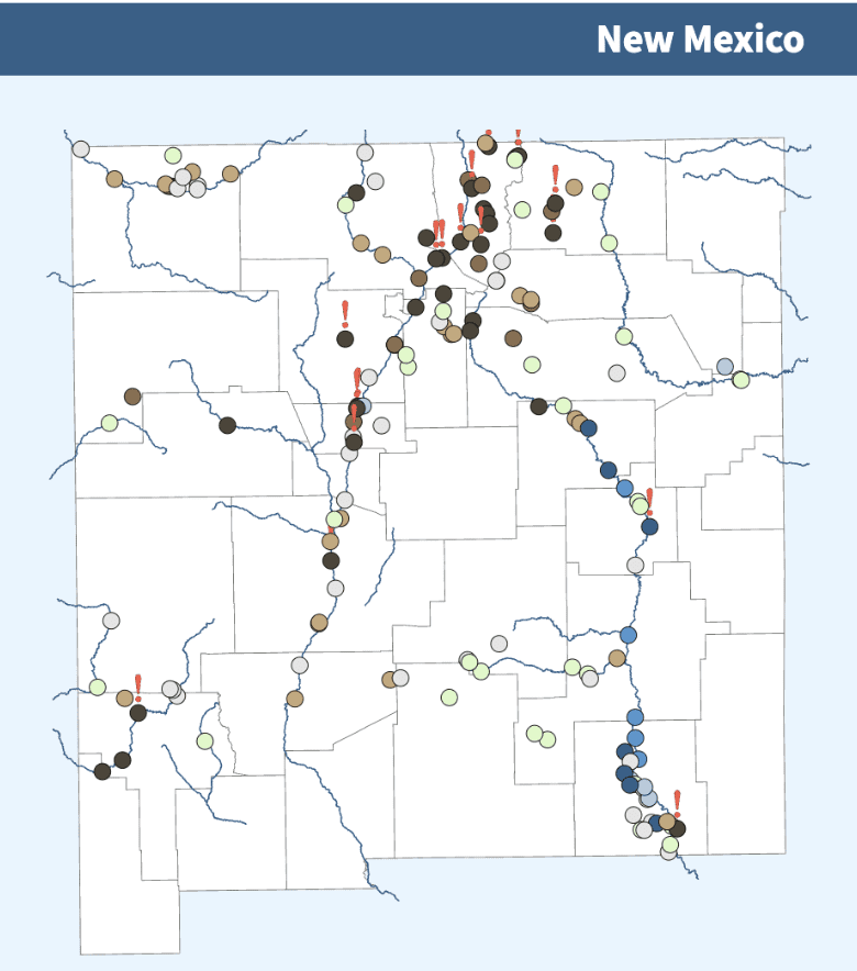
FIGURE – New Mexico water conditions from 153 USGS monitoring stations. Downloaded on April 28, 2026.
Scientists have been warning about warming, aridification, and increased water challenges for decades. And New Mexicans everywhere see the impacts of climate change in heat- and drought-stressed forests, dry riverbeds, burning landscapes, dust storms, heat waves, and bare mountaintops. Even if a so-called Super El Niño brings rains to New Mexico this summer, it won’t solve our long-term water challenges. Indeed, it will likely lay bare our vulnerabilities to extreme rains and flooding — and not just in places recently ravaged by wildfires.
In this moment, each of us must listen and witness. We must choose to take care of one another. And in these dangerous and challenging times, we must talk about how to better protect tribal water rights, sustainable agriculture, communities — and our rivers, streams, and wetlands.
During times like these, when people worry about their own water, competition and hardship weaken our ability to cooperate or care for another — let alone the more-than-human world.
But neglecting or harming our rivers and the species we share this Earth with doesn’t make us safer or stronger. It makes us weaker and far, far lonelier in the long run.
In this moment, each of us must listen and witness. We must choose to take care of one another. And in these dangerous and challenging times, we must talk about how to better protect tribal water rights, sustainable agriculture, communities — and our rivers, streams, and wetlands.
It’s easy to be overwhelmed by global and national events, while ignoring the influence we have in our own neighborhoods and communities. For example, how many of us called or wrote state legislators earlier this year, urging them to fund state agencies, protect rivers, address climate change, and take the state’s water challenges and inequities seriously?
With that in mind, there are steps anyone can take in this moment — to dispel despair and inaction. And to take part in a future that’s better for all of the state’s waters.
Visit (or recall) a beloved water body. Imagine a sustainable future for the river, stream, or wetland you love. Listen to what water is telling you.
Share your story and write to elected officials about how they can better protect the state’s waters. Explain why water is precious and meaningful to you and your community. Remember to hold elected officials accountable. Especially those you voted for or supported during election season.
Have an intimate conversation about what New Mexico’s rivers need and deserve with at least one other friend, neighbor, or family member. It’s okay to disagree. But keep talking.
In these dangerous and challenging times, it’s up to us to be brave, with love in our hearts, and listen to what water is telling us. Indeed, there is no real other way forward.
The United Nations has a name for what is happening to Albuquerque’s water supply. In January 2026, the UN’s think tank on water published a report concluding that the world has entered an era of global water bankruptcy. New Mexico is not exempt. The term was formally defined this year to be more precise and descriptive than the generalized term “water crisis.” Water bankruptcy is a state in which a human-water system has spent beyond its hydrological means for so long that it can no longer satisfy the claims upon it.
New Mexico Water Advocates submitted a White Paper to the Authority Board at its April 22 meeting requesting six actions to prevent Albuquerque’s pending water bankruptcy.
The first step in preventing water bankruptcy and adapting accordingly is to recognize the problem; that is, face the facts. In the late 1980s and 1990s, Albuquerque discovered and faced the relevant facts of the aquifer underneath it that was its sole water supply source. Now, reduced river flows of the Rio Grande and the three headwater streams since the turn of the century demonstrate the 1990s assumptions, which were also the Water 2120 assumptions, are invalid, overtaken by climate change. Albuquerque must again face the facts and adapt. As the 1997 Albuquerque Water Resources Management Strategy explicitly called for, Albuquerque should also help its neighbors.
Water 2120 Doesn’t Work with Climate Heating and Aridification
In 2016, the Authority adopted Water 2120, a 100-year water plan, concluding a major effort by Water Authority staff and several consultants. Water 2120 authors assumed that future water supplies would resemble the past — a condition water planners call stationarity. That assumption was visibly failing by the time Water 2120 was approved. It is now visible as dry riverbed sand and cracked mud in Valencia County. The river will dry at Albuquerque in May until drenching monsoon rains arrive, if they do.
Water 2120’s water supply strategy depends on the federal San Juan-Chama Project, which delivers water from the Colorado River basin through Heron Reservoir to augment municipal and irrigation water supplies in the Middle Rio Grande. The Authority has perpetual contract rights to half of the Project’s annual yield.
Direct drinking water use of the Authority’s share has two requirements. Both are failing simultaneously. Heron Reservoir ended 2025 at 7% of capacity, a record low. The absence of winter snowpack resulted in this year’s inflows to the reservoir also setting a record low. Runoff is over. Native Rio Grande flows are so low that the Water Authority’s river water treatment plant shut down on April 24 due to lack of sufficient streamflow to allow its diversions to continue. Since 2020, the drinking water plant has been unable to treat water for a sufficient number of days per year to meet its annual drinking water production targets.
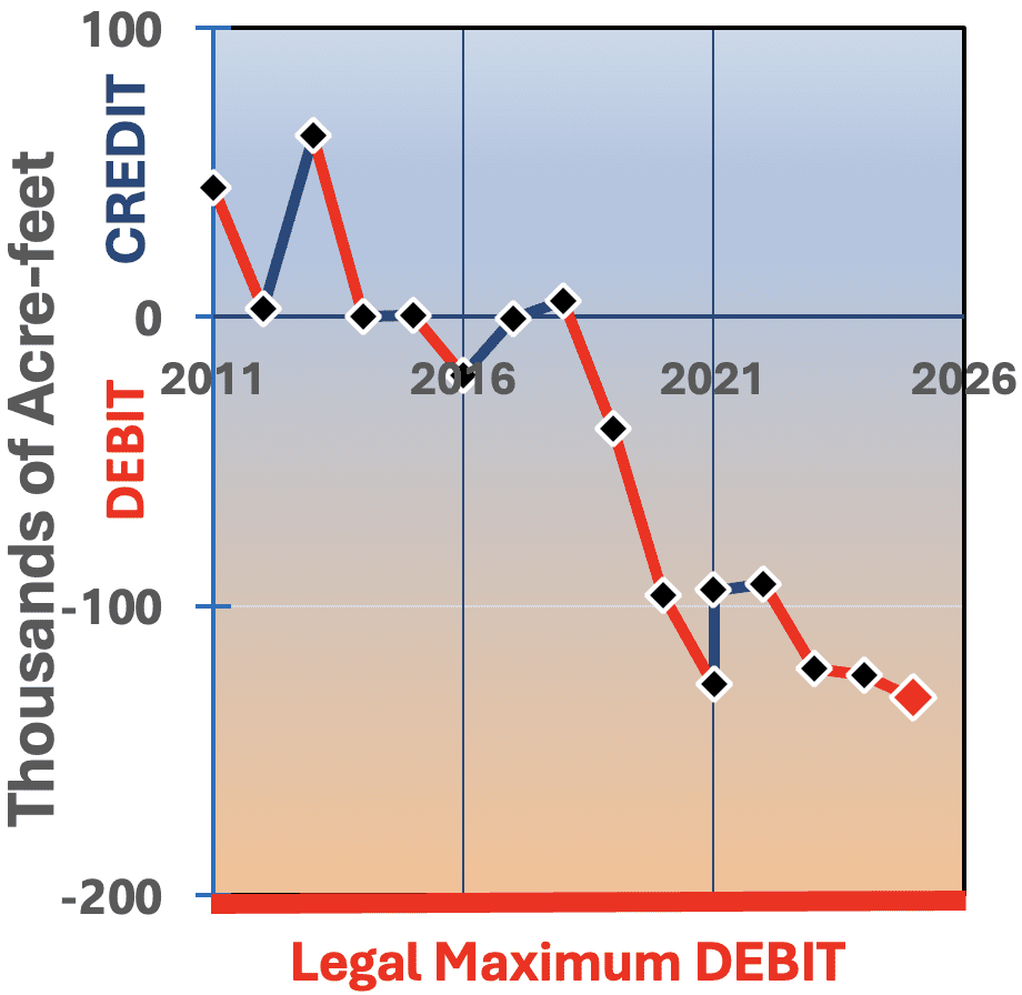
The Rio Grande Compact Clock Is Running
New Mexico currently carries a cumulative Rio Grande Compact debt of 132,000 acre-feet, accruing at roughly 20,000 acre-feet per year. A plain-terms Compact violation occurs at 200,000 acre-feet. At the current rate, that is three years away.
A Middle Rio Grande Compact violation will cause another Texas lawsuit heard by the United States Supreme Court. The Supreme Court again will become New Mexico’s water bankruptcy judge and Texas will have its full say.
The Rio Grande Compact obligates New Mexico to deliver water to Elephant Butte Reservoir for the Lower Rio Grande’s water users. Every Middle Rio Grande diversion from the river, every pumping well, and increased evapotranspiration from the river and riparian corridor draws against a common Middle Rio Grande legally available water supply that is smaller than the total demand. In retrospect, this trend has been visible for many years.
The Water Authority contributes a relatively small fraction of the Middle Valley’s total depletions. However, a compact violation is extremely risky and will bring big problems for the Water Authority. Water 2120 doesn’t recognize the overarching compact limits on total depletions or the effects of Water Authority planning decisions and operations on compact compliance.
The Water Authority Board Must Act
The Water Authority’s executive director has made recent public representations that the Authority can serve new high-water-use industrial customers. The Authority plans to consume more of its treated wastewater for non-potable irrigation that will increase its net depletions of the river. These public representations and plans to consume more and more of the Authority’s return flows for irrigation are contradicted by the Authority’s 2026 Operating Plan that recognizes the severe constraints of this year’s hydrology and the requirement for unsustainable groundwater pumping. Staff reported to the Board that fewer wells are currently in operating condition and that two old high production wells had recently collapsed and were ruined.
The Authority also faces a growing gap between revenue and expenses, a substantial backlog of deferred facility rehabilitation, and over $140 million in unexpended rehabilitation appropriations while costly failures divert resources from planned work. The Authority’s financial advisors are recommending new fixed monthly customer fees and increased debt financing at a time when debt service is already the Authority’s largest annual expense. The Authority’s revenue model depends on water and sewer commodity sales — creating a structural conflict between the conservation the situation demands and the revenue the Authority needs to pay its bills.
Water 2120’s foundational assumptions have failed. The Board has the White Paper. The NM Water Advocates look forward to the Authority’s response.
What We Are Asking — And What You Can Do
The New Mexico Water Advocates’ White Paper requests six actions by the Water Authority board:
a formal, transparent reassessment of Water 2120;
an inclusive stakeholder process to revise planning assumptions;
a suspension of the Authority’s representations about serving new high-water-use industrial customers until future Authority water supply adequacy is publicly assessed;
a reassessment of the current Drought Stage designations and the responses each stage requires;
a conservation focus on high water users and non-functional turf; and
a policy of cooperation and mutual sacrifice to prevent a Compact violation.
The New Mexico Water Advocates are asking elected and appointed leaders at every level to engage honestly with what the data show.
We are asking you to make your voice heard — with the Authority Board, with your elected representatives, and in your community. The Middle Rio Grande’s water future will be decided in the next few years. The choice to adapt to prevent water bankruptcy is still available. The time to act is now.
NM Water Advocates Workshop Review, March 19, 2026
Hannah Riseley-White, Director of the NM Interstate Stream Commission, and Nat Chakeres, the State Engineer’s General Counsel, deserve our thanks as public servants and State leaders with authority and responsibility to govern New Mexico’s waters, which are the public’s. They made an admirably frank and thoughtful presentation, supported by informative slides, at the Water Advocates’ Middle Rio Grande Compact Crisis evening workshop. The prior evening, they had left their agencies’ Open House event at Elephant Butte at 8:00 pm to drive home to Santa Fe. They have big jobs, a large state, and lots of water problems demanding their leadership and judgment.
They presented honestly, using their own data to document the rapidly advancing crisis the Water Advocates have been describing. Hannah called the situation dire. Nat acknowledged the metering order said to be coming almost a year ago is not yet ready. Hannah called it overdue. Nat said plainly, “we will be the bad guy when we have to be.” We are grateful for state leaders willing to engage this directly and this publicly.
The Numbers Aren’t Waiting
But gratitude and concern can coexist.
What makes the case more forceful is not the numbers themselves. It is that top State water officials presented them. That is what carries authority. New Mexico currently sits at -132,000 acre-feet of compact debt. A compact violation occurs at -200,000 acre-feet. The average annual trajectory over the last decade is -19,800 acre-feet per year. Since 2018, only one year has not increased the cumulative debt. The 2021 apparent improvement was due to a paper accounting adjustment — not wet water arriving at Elephant Butte. Nat put it plainly: “we have been trying to turn the ship.” The ship has much inertia. The currents are strong. The ship has not yet turned.
The ship has much inertia. The currents are strong. The ship has not yet turned.
At the current trajectory, a compact violation is three years away. Hannah showed snowpack at the 0th percentile on the evening of the workshop. That means this year’s snowpack holds less water on this date than ever recorded. The runoff is coming down and will be essentially over in April, when recent peak runoff has been around Memorial Day. EBID’s surface water allotment this year is four inches. Hannah put it plainly: we are in uncharted territory.
A Collection of Parts and Hopes
Against that backdrop, the state’s goal to maintain compact compliance remains a collection of parts and hopes. One hope they expressed without a visible plan is that a negotiation — with whom? — will find a voluntary, timely solution. Are the incentives for cooperation and shared sacrifice greater than the incentives to litigate? “A goal without a plan is just a wish.”[1]
Nat rejected leading with an administrative approach, emphasizing that voluntary efforts must be given a chance. He also said agency staff are actively working, as their professional responsibility, on how to administer the Middle Rio Grande. The reality is the State Engineer is not ready. Some legislators say the leaders are not acting with the urgency demanded to prevent the compact violation.
The State Engineer’s 2004 General Rules for Active Water Resources Management, including a framework for shortage sharing agreements, was upheld by the NM Supreme Court in 2012. Under these rules, as step one, the State Engineer establishes the Middle Rio Grande Water Master District. Step two, the State Engineer issues a metering order. Step three, the State Engineer promulgates additional rules specific to the Middle Rio Grande. The State Engineer has yet to take the first two foundational steps.
Nat and Hannah emphasized that getting more water to Elephant Butte requires Middle Rio Grande water uses — human and natural — to deplete less, but that alone is insufficient. The river must efficiently transport the Lower Rio Grande’s legal share of inflows to Elephant Butte Reservoir where deliveries are accounted. The Middle Rio Grande’s southern end, below Socorro, has a failed engineered channel constructed decades ago. The river now is perched between levees on an elevated bed of sediment. The conveyance losses in this reach are high, regardless of the season and flow.
Hannah cited the genuine work underway — $55M in state channel investments across four legislative sessions, applying the Strategic Water Reserve to purchase water rights, deploying the Active Water Resources Management framework including issuing the forthcoming metering order, and making regional water security planning functional and effective.
But the metering order is being polished instead of issued. Regional planning councils under the 2023 Water Security Planning Act are not yet formed, much less funded, with drafting still underway for the binding guidelines that will set forth how everything is to work. A state regulatory approach is contemplated. That’s important because the adverse outcomes of rigid priority administration will motivate earnest negotiations for better outcomes. Negotiated outcomes are a goal of the Active Water Resources Management Program, but they take motivation and lots of time. Do we have enough time, with the three years to a violation trajectory?
Notably, the Interstate Stream Commission, the State agency created and given strong powers by statute, has never, not once, deliberated this Middle Rio Grande compact compliance crisis nor the approach and policies the Commission should apply.
One audience member asked a technical question about leveraging New Mexico’s stranded accumulated “relinquishment credits” to store water or for some other advantage. That brought a smile to Nat’s face; he replied he has been thinking about this. He again emphasized our situation is unprecedented, and that a Bureau of Reclamation official told him nothing should be off the table. Plainly, however, there is no water to store, and conveyance losses for water stored in spring and released the following winter for delivery to Elephant Butte Reservoir are too high.
Naming the Problem
Although both Hannah and Nat acknowledged our situation is aridification, Hannah used the word “drought” and announced the ISC is preparing a “Drought Toolkit” as a resource for communities. We raise this as a concern that has consequences, not a quibble. Hannah’s message describing our situation as “drought” reflects the notion of temporary — the implicit message that better times lie ahead — without any rational support for that reassurance. To her credit, Hannah stated the overriding plain truth: solving any water resources problem first requires understanding the hydrology and investigating different future conditions. The plain truth the Water Advocates see is that climate heating is permanently reducing and increasing the rate of depletion of New Mexico’s renewable water supplies — bad too soon.
A problem misnamed is a problem misframed. Shouldn’t we plan for the worst and hope for the best?
Norm Gaume opened the workshop challenging the state officials to recognize we are experiencing aridification caused by climate heating. Droughts end. Aridification does not. The data presented that same evening confirmed it — conditions now are worse than projected for 2070. The five warmest summers on record have all occurred in the last eight years, and snowpack is at its lowest in recorded history.
A problem misnamed is a problem misframed. Shouldn’t we plan for the worst and hope for the best? We will soon find the Middle Rio Grande in water bankruptcy if we don’t.
What Comes Next?
We left the evening more resolved. The legal framework exists. Some of the right people are engaged and speaking honestly. The ship must be turned, modernized, and the capacity created to take those essential water management decisions and actions that only the sovereign State of New Mexico has the authority to take. The moment requires the translation of acknowledged urgency into a specific, timed, and accountable action plan.
The State Engineer’s creation of the Water Master District and requiring meters on all significant wells are the first two steps. When will we see them?
Legislators were in the room that evening — we encourage every Water Advocates subscriber to follow our moderator’s advice and invite yours for coffee. When asked how people can help, Nat noted that nobody shows up at the legislature to advocate for essential agency modernization and IT systems funding. Water resources management needs champions.
The river has a lot of sand to deal with, as Nat said in explaining the river’s chronic conveyance problems and losses. As New Mexicans who want the best for New Mexico, in balance with hydrologic reality, we see a lot of sand in the machinery of responsible and responsive State and local water resources governance, too. We are running out of time to move it.
[1] Antoine de Saint-Exupéry, author of The Little Prince (1943). Saint-Exupéry was also a pioneering aviator who navigated by maps and instruments — a man who understood viscerally that aspiration without method is insufficient.
Other New Mexico Aquifers Are in Post-Crisis Failure
We keep reading and hearing that the Rio Grande is facing a water crisis. So are other rivers in New Mexico, across the southwest, and around the globe. But, as pointed out in a 2026 article from a United Nations water institute,[1] “Water crisis has become the default label for almost any episode of water stress, from short-lived droughts to decades-long overuse of rivers and aquifers.” The UN author contends that many times the conditions frequently described are not a “crisis” but actually represent a “post-crisis failure state”: their critical water supplies have been depleted beyond their sustainable hydrological budgets.
For such conditions, the UN author proposes that instead of saying “water crisis” a more appropriate term for such declines in an aquifer is Water Bankruptcy. He equates consuming surface water supplies with making withdrawals from checking accounts, whereas using water supplied from aquifers as making withdrawals from savings accounts. Thus, when continued groundwater pumping trends toward depleting the available aquifer supplies, that condition is equivalent to approaching bankruptcy, a post-crisis failure state.
Climate Warming and the NM Water Supply
First, why should we be concerned about the future of the water supplies along the Rio Grande and elsewhere across NM and the SW? Clearly, as we read, the climate around the globe is warming at an increasing rate. As described elsewhere,[2] this is producing changes in our atmosphere’s global circulation patterns that are projected to make NM air temperatures much warmer, as we are now experiencing in 2026, with later winter and early spring feeling much like summer.
In 2022, a New Mexico Bureau of Geology and Mineral Resources (NMBGMR) report projected that[3], “Over the next half century, profound changes in New Mexico’s climate will affect water resources all across the state. All evidence suggests that surface temperature will continue to rise throughout New Mexico over the next 50 years. Most projections of statewide annual mean temperature are from 3°F to 7°F warmer than the late 20th century, and some high-end models predict even more warming.” That is bad news.
But even worse, a recent analysis[4] of “really good” weather data for seven-day periods in Albuquerque going back to the 1930s, found that “no seven-day period” in any year has come anywhere close to the National Weather Service’s determination that March 19 to 25, 2026 is about 28oF above any seven-day average. That is more than four times outside the normal range of variation in Albuquerque’s air temperature for any seven-day period. This points to the likelihood of even greater and earlier effects to NM water resources due to climate warming than anticipated in the NMBGMR assessment. Thus, we should be very, very concerned about the future water supplies along the Rio Grande, as well as across NM and the SW!
Groundwater Mapping and Monitoring in NM
Applying the concept introduced by that UN proposed terminology to NM we might ask, is the Rio Grande or other groundwater basins in New Mexico heading toward bankruptcy? To approach this question, information available online from the New Mexico Groundwater Dashboard (NMGD) can be helpful.
NMBGMR is New Mexico’s non-regulatory water science agency. It produced the NMGD to provide public access to a relatively comprehensive long-term set of groundwater mapping and monitoring data. As the site’s welcome message emphasizes, “Wells are our window into the otherwise unseen realm of groundwater. In addition to producing water, groundwater-level data can also be obtained from water wells that can help us manage New Mexico’s groundwater resources.”
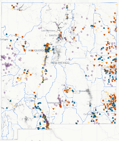
Figure 1: Groundwater Monitoring and Mapping in New Mexico, image of the NM Groundwater Dashboard
That site’s interactive map shows the locations of all of NM’s known groundwater wells and indicates for the wells that are monitored, which wells have trends of water level increases (green), decreases (red), or unchanged (yellow, Figure 1). Of the 268,405 wells located on that map, 2,323 have monitoring data. The site also reports that many of these wells are not specifically designed for monitoring; instead they are active production wells that also provide less accurate information on water level trends. The information on this site’s map comes from multiple sources, including monitoring data from the NM Bureau of Geology and Mineral Resources and the United States Geological Survey as well as the well locations from the NM State Engineer permit files.
Figure 1 shows that the greatest density of monitored wells along the Rio Grande is around the Albuquerque-Santa Fe reach and along the southern Rio Grande. Also, a considerable density of monitored wells (and particularly red icon wells representing declining water levels) occur in the eastern part of the state. Proportionally fewer wells and monitoring information comes from the area west of the Rio Grande drainage, with relatively fewer monitoring wells with red icons.
Clicking a colored icon on the dashboard brings up specific information for that well with additional options to display a graphic for the well’s aquifer water level over time and another graphic displaying the deviation (gain or loss) of these levels from the average for the well’s available data. An additional option is available to display the water level data measured for the well that were used to make the two graphics. Of note, groundwater depth information is not necessarily collected every year and some years have more than one measurement recorded. A few wells have continuous monitoring, including the intentionally installed three-dimensional network in metropolitan Albuquerque.
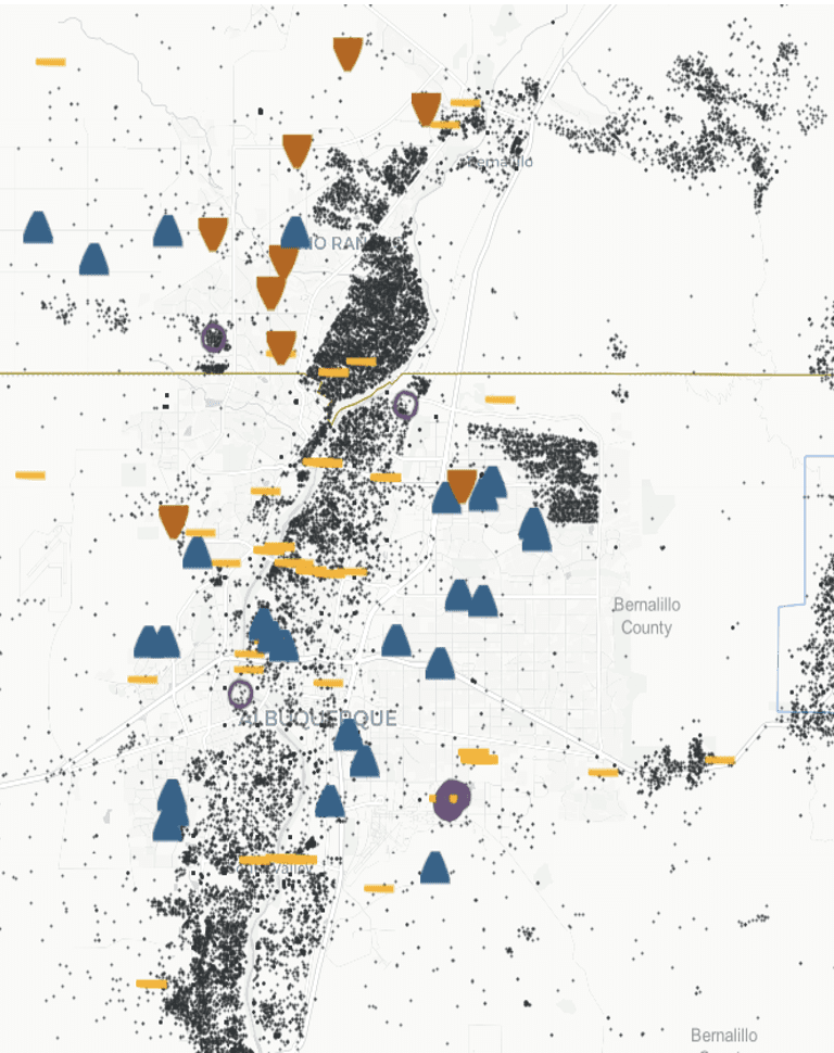
Figure 2: The Main Dashboard Map Zoomed into the Albuquerque metropolitan area.
Zooming in on the NMGD map (Figure 2) shows the actual density and locations of both monitored wells with colored icons and the density of black permitted well surrounding the Rio Grande and Albuquerque areas. Most of the icons in this area are blue or yellow indicating that the aquifer accessed by these wells is gaining or remaining largely unchanged based on the well’s monitoring data. There are relatively fewer monitoring wells with red icons.
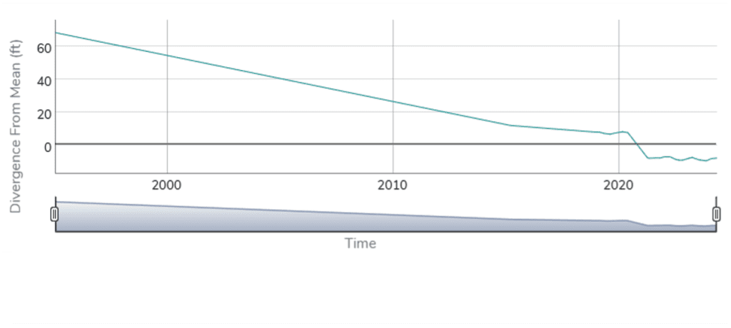
Figure 3. Water divergence from mean for the aquifer at a site north of Albuquerque.
Clicking on the red icon on the NMGD site for the well at the top of Figure 2, we learn it is a USGS monitoring well located in a remote area (GPS: 13N03E.21.3124). From 1978 to 2025, its aquifer has decreased to a current depth to water of 446.8 feet. That water level is 7.8 feet below the average water depth for the site (Figure 3). That suggests that the aquifer in this area is perhaps heading toward or is in bankruptcy under the UN defined term.
The Albuquerque Area Aquifer
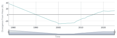
Figure 4. Water divergence from mean for the aquifer at a site in east Albuquerque.
Clicking on the blue icon on the NMGD site for the eastmost well in Figure 2 we learn that it is located 11N.04E.28.131 WKR 4, which is near the intersection of Academy and Eubank. This USGS monitoring well currently has a groundwater increasing trend, with a current depth to water of 714.83 feet that is 13.17 feet above average (Figure 4). Of note, however, the data for this well shows that from the 1970s to 2000 this aquifer had a continual trend of declining aquifer depth. In 2000 it started having a slow increase in water depth that started a more rapid rise in aquifer depth starting about 2017-2018 then leveled in 2020 through the following monitoring years in this data set.
From this brief review of the NMGD site data for these two sites and information from other monitoring well sites included in Figure 2 reviewed but not characterized here, it is reasonable to conclude that, at the present time, the Middle Rio Grande aquifer overall would not be appropriately characterized as in bankruptcy.
For some areas in the north and to the west (along the edges of the Middle Rio Grande aquifer), however, such a characterization would appear to be at or approaching appropriate. Plus, the fact that other parts of this aquifer displayed earlier periods of decline followed by periods of increase. That indicates the overall middle Rio Grande aquifer is of considerable risk of moving to bankruptcy should the current trends for climate warming and winter snowpack reductions, with early runoff, continue to decrease surface water supplies to the Rio Grande.
In fact, with the ongoing federal approach of viewing climate warming to be a hoax, not worth addressing, even greater threats of declining water supplies across the Southwest are increasingly likely. This argues that the regions along the Rio Grande require State water resource agencies to actively manage uses. Local governments must cooperate and take ownership of leading their constituents as soon as possible to conserve necessary long-term water availability for existing uses, including low water use economic development.
The High Plains Aquifer
In contrast, the preponderance of monitoring wells in eastern NM with red icons, indicating this region’s declining aquifer water levels, strongly suggests that these are aquifers in bankruptcy. The New Mexico State Engineer decided about a century ago that the State would allocate the water to use it for a reasonable time, which is essentially over. Groundwater expert Maurice Hall argues that the least we should do is plan for “graceful failure.” More than that is needed.
Without implementing active water management for regional water supplies, NM is likely to become characterized as having declining economic promise, perhaps with consequential depopulation trends. Alternatively, The State could wait for NM to somehow deliver one of its enchanted solutions for climate warming and our declining aquifers.
Needing more information?
Additional information on NM’s ground water resources is available from the NM Aquifer Mapping and Monitoring Program (AMMP) of the NMBGMR.[5] The information provided through this site establishes that, “By mapping aquifers and establishing a long-term monitoring network, the program generates essential insights into how groundwater moves, where it’s stored, and how it changes over time. Through the ongoing philanthropic support of the Healy Foundation, AMMP created the Collaborative Groundwater Monitoring Network. This network provides critical, baseline information on groundwater trends through collaborative data collection and regular measurements of depth to water across the state. State funding will enable this program to drill new monitoring wells in strategic locations, addressing questions about water quality, water depth, and filling critical gaps in subsurface knowledge.” The dashboard also presents additional information about this network including showing location of its sites across NM.
Unfortunately, software and security problems have caused the NMBGMR to post that its network of monitoring data for specific well locations currently are not generally available. That signals more need for state investments to improve, modernize, and secure water agencies’ data systems.
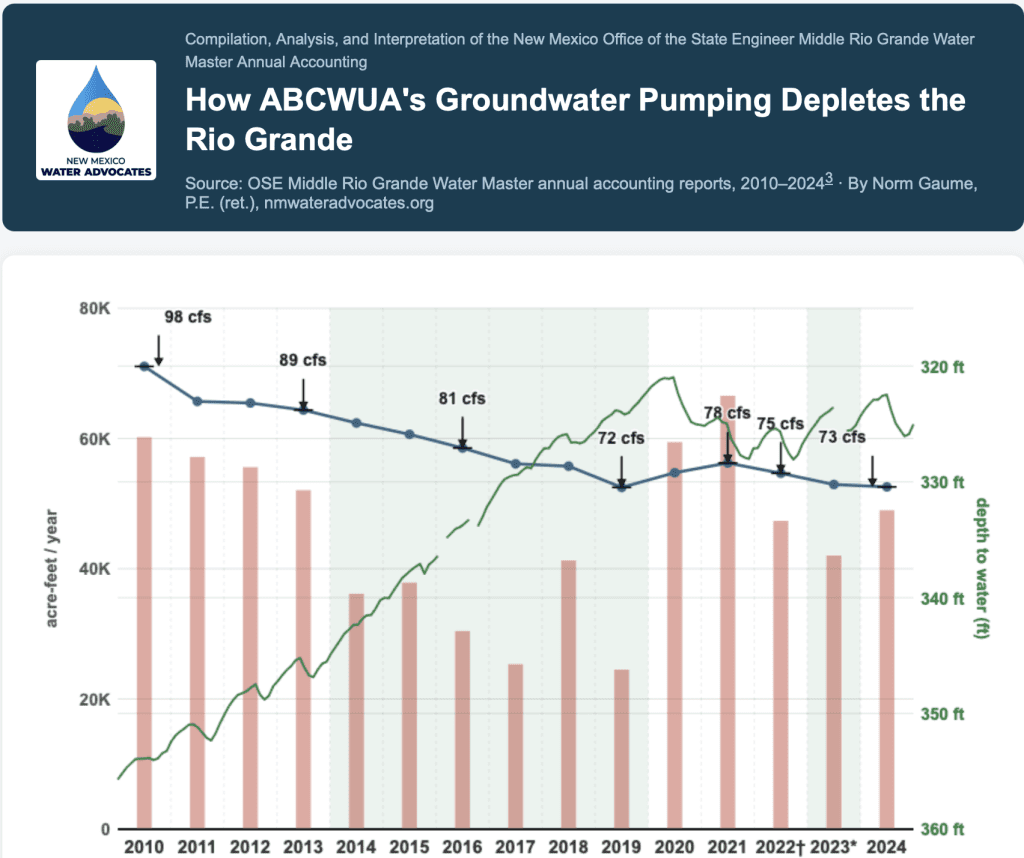
Fifteen years of annual water diversions and water rights accounting data prepared by the Office of the State Engineer Middle Rio Grande Water Master illustrate the outcomes of a remarkable but now threatened story of local water resources management. This chart shows how Albuquerque Bernalillo County Water Utility Authority (ABCWUA or Authority) groundwater pumping changes (red bars) caused groundwater levels to recover and reverse (green line), with a 25% reduction in the annual volume that ABCWUA current pumping and the residual of historical pumping depletes the Rio Grande (blue line).
This chart demonstrates the complex relationships among these annual variables:
ABCWUA total water demand, minus
ABCWUA Drinking Water Project treated surface water production
Determines the volume of ABCWUA groundwater pumping,
Which causes changes in the aquifer system, which in turn,
Determines the annual volume of Rio Grande water depleted by gravity pulling a portion of the streamflow into the aquifer to refill the merged cones-of-depression caused by groundwater pumping.
Groundwater Pumping
The red columns show the annual groundwater pumped by ABCWUA under its primary permit no. RG-960 that authorizes pumping from all ABCWUA water supply wells except the Corrales Trunk wells. Annual groundwater pumping dropped considerably from 2010 through 2019 as the Drinking Water Project ramped up production of treated river water. The diversions were the volume of San Juan-Chama imported water that the Authority had arranged to be in the river available for diversion plus an equal amount of native Rio Grande water required to be replaced downstream in real time with treated municipal wastewater.
Prior to the Drinking Water Project start-up in 2009, local groundwater was the sole water supply source.
From 2014 to 2019, treated river water supplied half or more of total demand, with ABCWUA pumping groundwater to make up the remainder. Starting in 2020, declining availability of the sustained Rio Grande flows needed for long seasonal operation of the Drinking Water Project has reduced the number of days it can operate, cutting the hours of treated surface water production thereby forcing higher groundwater pumping.
Aquifer Response to Changes in Groundwater Pumping
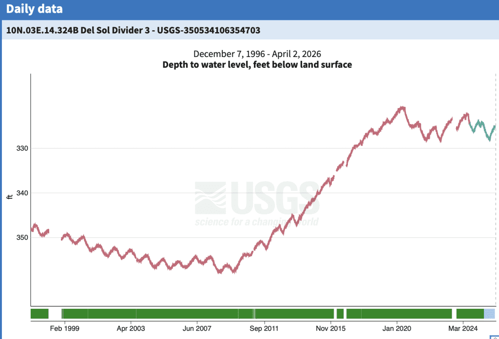
The green line in the chart above represents the mean monthly depth to groundwater measured from the middle depth of three USGS dedicated monitoring wells located in a neighborhood park on Albuquerque’s near east mesa. The location was selected to be as far as possible from adjacent well fields.
The USGS Del Sol Divider groundwater level data collection started in 1996 and has produced 30 years of record, illustrated in the chart below. The line shows the depth from the ground surface to the well water level. The USGS online chart below shows the continuous measurements. The maximum occurs in late winter; the minimum is observed at the end of hot weather and the irrigation season. Comparing the late-season minimum from one year to the next reveals whether the water table is recovering or declining
USGS Del Sol Divider #3 — site 350534106354703. Depth to water level, feet below land surface, Dec. 7, 1996 – Apr. 2, 2026.
The groundwater level dropped annually until about 2005 when the downward trend became less prominent, probably due to ABCWUA’s effective water conservation program. Then in 2010, with the Drinking Water Project start-up and production of 42,800 acre-feet of water from the river, the groundwater level didn’t decline with the summer pumping. The groundwater level recovered more than 30 feet between 2010 and 2020. The gains were more pronounced during the six consecutive years when the river provided half or more of ABCWUA’s annual drinking water supply.
Aquifer Recovery Stalled — 2020 to Present
Groundwater pumping shot back up in 2020 due to the lack of sustained Rio Grande flows needed to transport ABCWUA’s San Juan-Chama water to the Drinking Water Project intake. Conditions worsened: 2021, 2022, and 2025 were among the five driest years this century for Rio Grande water availability.1 The Rio Grande at Albuquerque dried for extended periods during the summers of 2024 and 2025 — part of the driest 17-year era ever recorded under Rio Grande Compact accounting — the first drying at Albuquerque in four decades.2 The Del Sol Divider water levels shown at the right side of the charts reflect this worsening of surface water availability through 2024.
How Much Aquifer Recharge from the River to ABCWUA Groundwater Pumping Cause?
After the USGS drilled a substantial number of monitoring wells throughout the Albuquerque area in a three dimensional arrangement and interpreted the aquifer’s complex, faulted geologic structure, the next step was to develop a three-dimensional computer simulation model linking the various layers of the aquifer, the river in the top alluvial layer, and deeper adjacent groundwater pumping from individual wells throughout metropolitan Albuquerque. The first USGS model was published in 1994. Many successive versions by the USGS and other modelers have followed, refined by installation of additional monitoring well nests and a lengthening history of measurements.
This monitoring shows the Albuquerque Basin groundwater flow system responds slowly to changes in annual pumping volumes. The induced recharge of the aquifer from the Rio Grande responds even more slowly to changes in pumping.
Historical pumping by the City of Albuquerque and successor ABCWUA removed vast volumes of water from groundwater storage. This pumping created a giant cone-of-depression, formed by the merging of the cones-of-depression of individual wells. The giant cone was broadly centered across the Albuquerque Uptown area and was 160 feet below predevelopment groundwater levels near the Sandia Mountain front.
The Office of the State Engineer developed an improved version of the USGS model and operates it annually, after the year has passed, to calculate how water flowed from the river to the groundwater system that year in response to pumping in the current year and historically.
The blue line in the main chart shows the modeled depletion of the Rio Grande caused by the most recent years and all historical pumping from ABCWUA system wells. For example, in 2010, 71,100 acre-feet flowed from the river to the groundwater system, which corresponds to a continuous flow of 98 cubic feet per second. The total groundwater pumping was 60,200 acre-feet and the Del Sol Divider’s monitoring well showed the water level was 354 feet below the surface.
Contrast that with 2019, the 10th full year of Drinking Water Project operations prior to the worsening water scarcity of the 2020s. Groundwater pumping was only 24,500 acre-feet. The Del Sol Divider water level had risen more than 30 feet. The induced flow from the river to the aquifer was down 25% to 72 cfs. That’s significant river and stored groundwater conservation.
Recent extreme surface water scarcity has caused this early progress to falter. Further substantial declines in the Del Sol Divider groundwater level are expected as aridification takes hold.
Conclusions
Aridification has invalidated major assumptions about the availability of surface water for the Drinking Water Project and its ability to permanently and reliably supply more than half of total demand — thereby substantially reducing ABCWUA’s dependence on local groundwater. These assumptions were central to both the planning that produced the Drinking Water Project and to the 2017 100-year water plan.
A 10-year update to that plan is due next year. This analysis makes clear that the situation requires a fundamental overhaul, not merely a routine update. Additional imperatives not discussed in this article concern the adequacy of ABCWUA’s water rights portfolio and ABCWUA’s obligations relative to other major water users under any Middle Rio Grande compact compliance framework.
Endnotes
1. 2021, 2022, and 2025 were three of the five driest years this century for New Mexico’s Rio Grande water availability. Data for the last 26 years were screened for the lowest annual volumes measured at the Otowi stream gage and below Elephant Butte Dam. The other driest years were 2002 and 2013. See also: Bardwell & Gaume, “Lower Rio Grande Water Settlement — New Mexico Water Advocates” (nmwateradvocates.org/lower-rio-grande-water-settlement-drinking-water-taxpayers-pecans/). For a broader aridification context based on 85 years of Rio Grande Compact accounting at the Otowi gauge, see: Gaume, “The Rio Grande at Its Driest: What 85 Years of Compact Data Show” (nmwateradvocates.org/rio-grande-driest-era-compact-history-otowi/).
2. Based on USGS stream gage 08330000, Rio Grande at Albuquerque. Consecutive zero-flow days were recorded in summers of 2024 and 2025 — the first such occurrences since the early 1980s. Channel drying downstream worsened with distance.
3. The OSE Middle Rio Grande Water Master annual accounting reports are not posted online. The Water Master provided digital copies for individual years. The author compiled them in the linked Excel workbook that was the basis of all analysis.
4. Per the ABCWUA Water Resources Management Strategy, the 100-year plan is subject to a 10-year update cycle. The 2017 plan update is due in 2027. ABCWUA is currently working on the revision. There are no mechanisms for public comment except the Board’s normal acceptance of comments at all public meetings.
This article and the main graphic are accurate within the limits of the input data. Graphic prepared using AI tools by Norm Gaume, P.E. (ret.), NM License No. 6969, retired New Mexico water resources engineer and President, New Mexico Water Advocates. April 6, 2026


 La Niña is the term for that part of a repeating cycle of cooling and warming of ocean waters in the east-central tropical Pacific that repeats every few years. La Niña patterns occur when the water is coolest, alternating with El Niño patterns that develop in the warmest years of this cycle. Historically, the global climate changes caused by La Niña conditions typically include reductions in rainfall across the Southwest during its traditional summer monsoon season. An El Niño can increase later summer and fall monsoons for the Southwest. Of major significance, an El Niño generally leads to significantly greater snow packs in the southern Rockies. Such changes also accompany increasing drought conditions for the northern Rockies and much of the Northwest, Midwest, and East.


 The average annual trajectory over the last decade is